Thursday, July 28, 2005

Much-needed rains and cooler weather

Just when our drought situation was getting bad, much-needed rains fell over southern Wisconsin nearly every day beginning Wed. July 20 and finally ending last Tuesday, the 26th. 3.46 inches fell at the airport in Madison over this period, spread fairly evenly during the seven days, entirely transforming the landscape from brown grass and hard, cracked ground, to green and moist. Although some of the rainfall events recorded in Madison were from spotty thundershowers with other areas remaining dry, almost everywhere in the southern part of the state recorded at least 2 inches of rain over the week-long wet period, with some isolated locations in Grant county in the far southwest receiving close to 10 inches.

Rainfall in Madison at the airport from July 20th to 26th:
20th: 1.17
21st: 0.75
22nd: 0.00
23rd: 0.53
24th: 0.01
25th: 0.88
26th: 0.12
Total: 3.46

Besides the end of the drought, the hot weather ended for a while as well, although highs near 90 look possible again for Sunday through Tuesday. Yesterday afternoon felt like fall though, with sunshine, low relative humidity, and a high of only 74 degrees in Madison.

Friday, July 15, 2005

Statewide Drought Emergency Declared

Governor Doyle announced a statewide drought emergency today, with parts of southern Wisconsin in moderate and extreme drought conditions. Since April 1st, Madison has received only 7.60 inches of rain which is 5.39 inches below the normal for this period, the second driest such period on record. Sheboygan and Kenosha had their driest April 1st to July 15th period on record, but due to rainfall in the last few days, Milwaukee only had their 10th driest such period, still near long-term drought conditions though.

Because of the extremely dry conditions, the fire danger will be elevated for at least the next few days.

Unfortunately, there's just a chance for rain on Monday, and after that it may be dry for several more days. In addition, there should be a brief cooldown for Monday and Tuesday, but by next Wednesday through Friday it could be back into the 90s.

The counties along Lake Michigan have been spared the hot weather the last few days that the rest of the state experienced because of a persistent easterly flow on the back side of the remnants of Dennis. However, Lake Michigan is so warm now, about 72 degrees adjacent to Milwaukee, that the lake has begun to keep the lakeshore counties warmer at night. The lows in Milwaukee the last three mornings with the easterly flow off the lake have been 69, 68, 70, and 70, while in Madison the lows for those days have been 65, 65, 66, and 58. With Dennis continuing to weaken and move away, and a weak front approaching from the west bringing a southerly flow to the entire state, expect the effects of Lake Michigan to decrease this weekend for the lakeshore counties. Afternoon temperatures will begin to climb to near the levels that the rest of the state has been experiencing.

Monday, July 11, 2005

Rain from Dennis will stay mostly in Illinois

Around noon today cirrus clouds from the outer remnants of hurricane Dennis began to move north across the area, holding the high temperature in Madison to 88 degrees, but areas farther south where the clouds moved in earlier were cooler, such as Monroe and Mineral Point both at 84. Some areas in the central and northern parts of the state where clouds had not yet arrived reached the lower 90s. Eau Claire, Wausau, Green Bay, and Rhinelander all reached 91 this afternoon.

Winds switched to predominantly an easterly direction ahead of the approaching circulation of Dennis, which helped hold Milwaukee to a high of 83.
Southern Lake Michigan surface temperatures are now around 70 degrees though, so the amount of cooling from an easterly wind is much less there now than it was a month or two ago.

St. Louis is currently receiving a good soaking rain from the remnants of Dennis, and outer bands of showers have reached as far north as Bloomington-Normal Illinois, but it looks as the Dennis will soon stall and only spread scattered showers into Wisconsin. The increased cloud cover and possible showers will hold down high temperatures for the next couple of days, but it looks unlikely that we'll receive enough rain to green things up around here very much.

Eventually Dennis will dissipate as it moves very slowly to the east, and so hotter weather may return for Friday, Saturday, and Sunday. It's still a week off, but it appears that a significant cold front may come through around next Monday and suppress the heat back to the south and west for a while.

Saturday, July 09, 2005

Satellite image of Dennis 2:15pm Sat. 7/9/05

Low 90s possible by tomorrow and Monday

Yesterday was the last day of cooler than average weather that we will see for at least several days, possibly longer. Although the month started out with pleasantly cooler weather, our high temperatures in Madison for the first eight days of July have averaged 78.5 degrees, still nearly two degrees above the 76.7 we saw in the first eight days of July last year. The next week will be significantly warmer.

Today the high will likely reach the upper 80s, although humidity values will remain low at least for one more day. Humid, hazy weather that we had so much of in June may hold off until at least Tuesday or Wednesday as the remnants of Dennis approach from the south. Our forecast for midweek still depends on the exact track of Dennis, with current indications pointing to rains remaining to our south in Illinois and hot weather prevailing here.

If the humidity remains low for tomorrow and Monday, temperatures could climb into the lower 90s, with possibly even some mid 90s. So, why is it that daytime temperatures are warmer and nighttime temperatures cooler when the air is dry?
Here's your scientific explanation: The specific heat capacity of water vapor is nearly 4,000 J/kg, whereas the specific heat capacity of dry air is around 1,100 J/kg, or more than three times less. This means that it requires much more energy to heat up air with a lot of water vapor, humid air, and with the higher heat capacity, it takes longer to cool down at night.
Here is an example:
New Orleans, Louisiana, has a humid climate because of its close proximity to the Gulf of Mexico. This time of year, it averages a high of 91 and a low of 74, a daytime range of 17 degrees.
Tucson, Arizona, on the other hand, which typically has much drier air, averages a high of 100 and a low of 73 this time of year, a daytime range of 27 degrees.
Humidity is not the only control on daytime temperature range; cloud cover and other factors can also be important.

Thursday, July 07, 2005

Eventual track of Hurricane Dennis to determine extended forecast for Wisconsin

Hurricane Dennis has been strengthening in the Caribbean Sea and is now nearing the southeastern tip of Cuba. It's brought some torrential rainfall and high winds to Jamaica, but the eyewall remained out to sea, sparing Jamaica the worst. I haven't heard reports yet from Jamaica, but I'd guess there will be some flooding and major damage to parts of the northern coast of the island.


Visible satellite imagery of Dennis as an eye started to become visible at 9:45am. The images are available at the National Hurricane Center website.


Visible image from 3:45pm this afternoon. The eye is cloud-filled, but the overall structure of the storm has improved from this morning, at this point now classified as a major category three storm with top sustained winds of 115 mph.


The National Hurricane Center 5-day forecast for Dennis. Forecasting the track of tropical cyclones is notoriously difficult. Interactions with land (such as will occur soon when Dennis makes landfall on Cuba) can decrease the intensity and cause unpredictable changes in the track.

Dennis' connection to the weather in Wisconsin:
The medium range computer forecast models have not agreed on a solution, but it appears that a farther eastward track of the remnants of Dennis next week toward eastern Virginia (as a model run this morning showed) would pull in cooler air from the north into Wisconsin, giving us another nice break from the heat.
On the other hand, if the remnants of Dennis stall in Kentucky and southern Indiana, as a model run this afternoon showed, any penetration of cooler air into Wisconsin from the north would be blocked and the hot weather that is expected to develop later this weekend would continue.
It appears that in either case, there's an above average shot at more hot weather by about a week from Saturday, Jul. 16th, possibly a heat wave developing.

Wednesday, July 06, 2005

Cooler weather continues in Madison and south central Wisconsin, won't last long

The cooler weather over the fourth of July holiday weekend was a welcome break in south central Wisconsin from the persistent hot weather of June. The average high over the first five days of July in Madison has been 77 degrees, four degrees below normal. There was a little rain on Monday, 0.28 inches at the airport, but much more is needed to alleviate the drought conditions that are developing. Last night there was some spotty heavy rainfall in western and southern parts of Madison that dropped up to half an inch where I live on the near west side, but it was extremely spotty, so that if totals are averaged from over all of south central Wisconsin (most of which were dry), the amounts are negligible.

June 4th warmest on record in Madison

June averaged a high of 83.3 and a low of 61.2 for an average temperature of 72.3. This averages 5.3 degrees above normal for the month, the fourth warmest June on record since records began in 1869. Our 72.3 degrees beats out the 72.0 degrees measured in 1995, which was the last really hot summer in recent memory (remember the July heat wave that killed hudreds in Chicago that year). In fact, it's the warmest summer since 1934, which had an average of 73.1 degrees. We were far below the incredibly warm June of 1933 though, the warmest on record, which had an average temperature of 76.0.

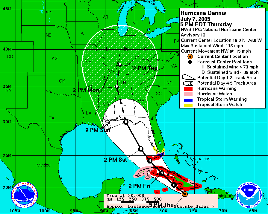
Although July has started out cooler than normal, it doesn't look like it's going to last. By Friday, highs are forecast to be in the mid 80s, above the seasonal normals of around 82. The longer term forecast is more uncertain, as always, but it appears that Sunday through Tuesday could be a hot period with highs near 90 each day. The computer forecast models have been fluctuating in the even longer term, originally showing some cooler air settling in from the northeast. However, the most recent forecasts are indicating that newly upgraded hurricane Dennis may crash into the central gulf coast around Monday morning, then head due north in the direction of Wisconsin. It's a long shot that we would get tropical precipitation associated with the remnants of Dennis late next week, but more likely, the hurricane remnants could prop up the hot ridge and keep a cold front from dropping in from the north. If the hot-looking extended forecast holds up, it looks like July may end up being another hot month in south central Wisconsin, maybe leading to a record warm summer. We'll have to wait and see........

Record warm great lakes temperatures for June

An article in the Detroit News on Sunday highlighted the unusual warm temperatures that are affecting all of the great lakes: http://www.wzzm13.com/news/news_article.aspx?storyid=41591
Water temperatures in all of the great lakes in late June were near their normal seasonal peak values, which usually occur from around late July into early September. If July ends up being hot, water temperatures could approach record high values. That would be good for swimming, but bad for fishing.
The Lake Mendota surface temperature on June 20, according to the UW limnology department was 75 degrees, equal to the highest reading observed all of last year, which occurred in early August. If the rest of the summer is hot, count on Lake Mendota feeling like bath water.

Global warming?

Although this summer is looking like it could be one of the top ten hottest in Madison, remember that last summer (2004) was one of the coolest on record. Also remember that it has snowed on May 2nd each of the last two years, with a trace this year and 1.2 inches briefly covering the ground last year, hardly an indication of global warming. There has been a strong trend in the midwest over that last 25 years toward warmer winters, but summers have not seen a similar trend. Precipitation has increased somewhat during the summertime though.

Arctic the place to watch

The summer and early fall of 2004 had the smallest areal extent of Arctic sea ice on record, continuing a trend in the Arctic toward less sea ice in the late summer, its time of least extent. Sea ice extent has changed little at its greatest extent in early spring, however. By May of this year, snow cover was near a record low areal extent in northern Canada, and by this week, snow cover was confined to the very northernmost islands of the Canadian archipelago, well below average. Hudson Bay is nearly all melted, earlier than normal, and Arctic sea ice is looking like it may challenge last year for the least late summer extent on record.

Why should we care about the Arctic? Hardly anyone lives there.

The snow and ice conditions in the high arctic can have an impact on the climate of the midwest. Arctic sea ice and snow cover reflect much of the incoming solar radiation. When the sea ice and snow cover isn't present, much more solar energy can be absorbed at the surface, and when this occurs over a large area, large increases in surface temperature can result. Cold weather in the winter in Wisconsin is the result of bitterly cold and dry air masses that form in the high arctic and northern Canada, and when the jet stream allows, plunge southward. Decreased summertime snow cover and sea ice extent keeps the weather warmer longer in the fall in these far northern areas where cold air masses form. This can delay and prohibit cold air from plunging into Wisconsin, and thus give us warmer than normal falls and winters. Earlier melting in Canda such as what happened this April can give us warmer springs. But is this really global warming? It's really hard to say. It could just be a decadal trend. The weather over the next decade or two will probably give us a good idea where we're headed.

Tropical Watch

The hurricane season in the Atlantic basin has started with a bang this year. In fact, the four named storms so far this season (as of July 6th) is the earliest date ever with four named storms. Tropical storm Cindy hit southeastern Louisiana and southern Mississippi this morning with sustained winds up to 70 mph causing power outages for up to 250,000 people. Large tree limbs were down throughout New Orleans and residents were advised to stay home from work today so that cleanup crews could clear roadways. Cindy is currently moving up through northern Alabama and expected to continue spreading some heavy rainfall although winds have weakened. Hurricane Dennis is the main concern now, expected to hit Jamaica tomorrow and possibly hit the central gulf coast by late Sunday or Monday. If it continues to strengthen, it could be a category three or four at landfall, unusually strong for this early in the season. This would be due to a combination of near perfect conditions for hurricanes in the Caribbean and Gulf of Mexico, including warmer than normal sea surface temperatures and little or no wind shear that tends to weaken storms.