When will the cold weather begin?
There was a cool period a week ago, October 6-10, where temperatures were a few degrees below normal, but other than that we continue to have very mild weather this month. The temperature has dipped into the 30s several times at the airport in Madison, and the first official frost was actually recorded yesterday (Oct. 16) when the airport reached 32 degrees. There are still annual flowers blooming in my neighborhood though, so it must not have been too widespread.
In Milwaukee, the temperature has not yet fallen below 40 degrees this fall, rather unusual for this late in the season but not unheard of.
After a few showers this morning, the weather should become partly to mostly sunny and warm through the middle of the week, with highs around 70 degrees. The weather will cool down later in the week with rain possible and highs falling back toward the 50s.
We know the weather is going to cool down soon, but when are we going to slide into that well-known continuously chilly and often cloudy late fall weather that is so typical in Wisconsin?
Well, since weather is not forecastable beyond about a week, it's hard to say, but the way things are going, sunny and warmish weather may keep returning off and on between cool snaps for another month or more.
Moving on past the next few weeks toward winter, according to the national climate prediction center (CPC), most of the central part of the country is likely to get an above normal winter.
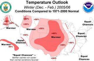
However, the most reliable forecast tool, El Nino and the Southern Oscillation, or ENSO, is expected to remain in a neutral phase this winter, limiting the long-term predictability of weather patterns over North America. During times when there is a strong El Nino, or much higher than normal sea surface temperatures off the coast of Peru like in 1997-1998, the northern US is known to have much warmer than normal winters. However, in the absence of a strong El Nino, the CPC has fewer tools at their disposal to predict the climate. From reading their forecast discussion, the warmer than normal forecast for most of the western and central part of the country is due to "interdecadal trend", meaning the on average winters have been above normal for the last several years, so there is some skill in predicting an above average winter this year. In addition, warmth over the western part of the country may be somewhat amplified this winter due to a connection from warmer than normal sea surface temperatures over the subtropical Atlantic (where all the hurricanes have been forming).
posted by fennimore at 8:14 AM
5 comments
![]()
![]()

